Note: Subscribers reading this in an email, you can on click on the title above to go to the actual web site page for better layout and larger images.
If you don’t love maps, read no further. This short aside from our regular articles concerns four maps of Rancho Huichica—which was sold to Jacob Leese—over forty years time, from 1844 (or earlier) to 1885, that helped me and others before me locate the Padre Trail.
When I had found out that the trail (instead of a natural feature like a ridge line or creek bed) represented the top most boundary of the rancho, I wanted to confirm that. So I hunted for maps of the rancho online and elsewhere, including the Bancroft Library (where I did hold Map 1 below in real life—it is only about 8×10 inches). Here is the progression.
See how the rancho grows
MAP 1:

Map 1 is a diseño drawn to show the basic area of the grant. Original rancho grants were not surveyed—their maps were hand drawn with pen, charcoal, and water color like this one and incorporated physical landmarks as locators for its limits. Note that this north boundary is open and only goes to the hills, the west boundary goes to Arroyo Seco Creek, the south to the wetlands of the bay, and the east to Carneros Creek. The road from Sonoma Valley to Napa Valley is highlighted by me in yellow (all road highlighting below is mine, too). It’s likely this map does not include the hills because the grantee was interested only in the valuable grazing lands between those hills and the bay. This map is dated as “filed” in 1861 by the Bancroft Library, but it is so simple in its representations and does not include known information from 15 years before that (see 1844 maps below). So I think perhaps it was filed in 1861 as support material for a land case, perhaps to show history of ownership, and that is the reason for filing date. There is no date on the diseño itself. My guess is 1842.
MAP 2:

Map 2 is also a diseño and is dated 1844 under the word Huichica at upper left and was made by Gaspar Farrell, “agrimensor y arquitecto” of San Rafael. The south and west boundaries stayed the same. But, the grant now magically extends all the way west to Sonoma Creek (and, “coincidentally,” the planned embarcadero for Sonoma) and well north into the hills to the…Padre Trail (highlighted in green). I love the beautiful hand-drawn italic serif type on the top road that read Camino de arriba pa Napper: “Upper road to Napa”.
Because this map is so different from Map 3 below, a much more accurate map that was actually surveyed, I initially thought this “Upper Road to Napa” might not be the Padre Trail, but another road that was south of it. But it appears this is just an inaccurate map and the upper road is the Padre Trail because another version of this map (below) came to me from local historian extraordinaire Floyd Stone as a xerox copy.
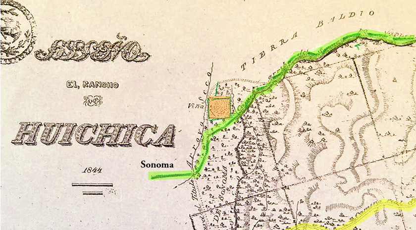
You can see it is basically the same map as #2 (though redrawn) with some detail added outside the upper left border to better locate the north edge as actually being the Padre Trail. The most important of those items is the square plot of land that is called “Kelsey’s Vineyard,” which I have shaded in orange. That strangely oriented piece of property is not part of the rancho but impinges on it. And, it shows up below on Map 3.
So probably to clear up that question of which road it was and where exactly that road started, Farrell updated the original 1844 map with Kelsey’s Vineyard to show that vineyard property (called Viña here). One other interesting item on this map is at the top center: the steep, hilly land north of the green road is Tierra Baldio: wasteland.
MAP 3:
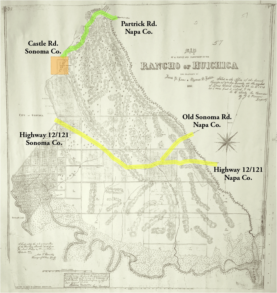
Map copy courtesy of Napa County
Map 3 is from 1851, and is an actual survey of the rancho made for Leese and his partner Thomas Larkin, and we again have the Padre Trail (green highlight again) and the top boundary of the rancho properly located (with Kelsey’s Vineyard in orange). Also plans are afoot here for a small town called St. Louis on Sonoma Creek (far left) around the embarcadero (in what is now the area of Schellville and the intersection of Highways 121 and 116). Whether it was a serious plan or not, it never came to fruition. Leese and Larkin sold most of the rancho during the 1850s.
This map likely informed the one below as notations on it say it was resubmitted in 1874 and the below, fourth, map came out in 1876. Map 3 was also resubmitted as valid in 1885.
MAP 4:
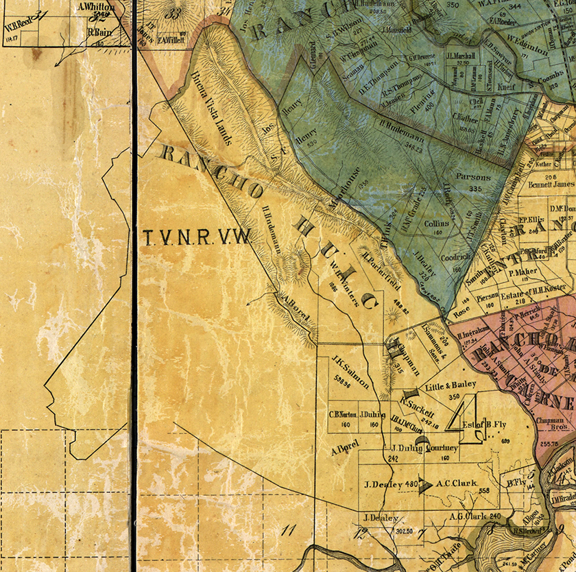
Map 4 came out in 1876 as part of the first map of the entire Napa County (this is a detail of just the Rancho Huichica section). You can see, however, that while the Padre Trail forms up upper limit of Rancho Huichica, it is not named or shown on the map. It is only the Huichica maps that actually name it and show it. Also, according to Stone there is no map of Rancho de Napa that shows the trail’s route once inside that rancho. One map shows where trails cross the boundaries but not how they continue, so can only conjecture what the trail did once inside Napa County based on terrain and likely destinations.
For historical purposes, this map and one from 1896 and from 1915 (don’t worry I am not showing those, too) were important for history buffs because they listed the owner of each property outside city limits. They are a real help in finding out who owned what and when over 60 years. The parcels were still large enough then for that because they were subsistence ranches, farms, and vineyards, and had not be sub-divided so much that such notation would be impossible.

One Comment Add yours