Main photo above or at left: History buffs walk the course of the Padre Trail toward the Sonoma Valley in the distance (with permission from property owner).
The history of the Padre Trail
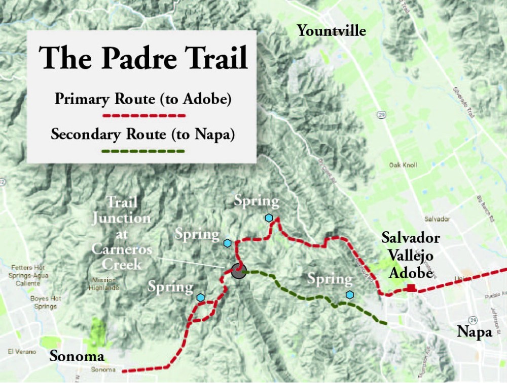
From the start of my interest in this area, neighbors and other history buffs had told me about what they called the Padre Trail. In the late 1820s and then 1830s, this trail had gained use by the Spanish and Mexicans at the mission in Sonoma. From Sonoma, it climbed the Mayacamas range between the Sonoma and Napa valleys, crossed the crest at the head of Carneros Creek near the end of what is now Partrick Road, and then dropped over a pass to the north into the Napa Redwoods near what is now Hess Collection Winery.
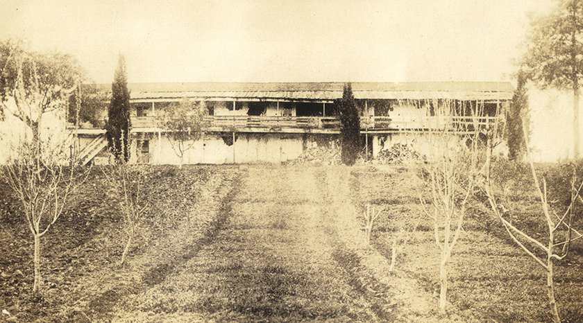
From there, it followed Redwood Creek downstream, where it passed a secondary adobe (more like a barracks or bunkhouse) owned by Salvador Vallejo, as it exited into the Napa Valley. From there, travelers could cross the valley floor to Salvador’s main house “Casa Las Trancas” on the Napa River, just north of today’s Trancas Ave. (Trail shown in red on map above.)
Later, with the arrival of the United States and the founding of the town of Napa, a secondary branch became more important. From Carneros Creek, it descended the route of Partrick Road (apparently called the “Browns Valley Indian Trail” at one time) into Browns Valley in order to more directly reach the town of Napa. (Trail shown in green in top map.)
It was called it the the Padre Trail because, they said, it had been used by the padre and noviates at the Sonoma Mission to visit the Napa Valley in order to preach and to probably visit George Yount, who had been granted land there by General Mariano Vallejo, and perhaps Salvador himself at his adobe on the Napa River.
Whatever its name now, or then, the trail (in both iterations) was first made around 8,000-10,000 years ago when Native Americans arrived and then used for hundreds of generations before the arrival of the Spanish. Today, gophers that dig around a spring along the trail continually push up arrowheads, sign that the spring was used by the tribes of the area.
The first padre to use the Padre Trail
The first European’s mention in a journal of the trail was that of Padre José Altimira who had been given—or assumed—the task of setting up a mission in Sonoma. It was obvious to all that Spain’s control of California was costing too much money, and the United States was already looking with desire at completing its hold clear to the Pacific Ocean. Many wondered what was the point of starting another mission. But Altimira would not be dissuaded. He found the climate of San Francisco unhealthy and depressing to converts, and wanted to build an entirely new main mission for the Bay Area.
In 1823, Altimira selected the Sonoma Valley as the likely location of this new mission. In order to assess the best uses for the land around the future mission, the padre led an exploratory party of 19, including sixteen Spanish soldiers in full uniform, east from Sonoma across the lower reaches of the hills along the bay to explore lower Napa Valley and over the next ridge into the Rockville area to meet the native Patwins there.
Altimira’s group returned by the same path, but west of Napa, attracted by what they thought were outcroppings of limestone—and thus a possible source of building blocks to use in constructing the town to come—they came up what would later be called Carneros Creek. (Carneros Creek got its name when, well downstream from the Padre’s exploration, the low, rolling lands became the pasture land for the mission, an area where all manner of hoofed meat animals were grazed. The area is now covered with vineyards and lends its name to an entire wine region across southern Napa and Sonoma counties.) After looking at the rock—all decided it must be limestone, but were apparently wrong—they continued upstream along the creek below the steep uplifted escarpment that marks the Carneros Creek Fault, and climbed nearly 1,000 in elevation to the northwest end of the valley. There they found a trail crossing their path, and turned left on it, southwest, and followed over the ridge to Sonoma Valley. So it happened that Altimira became the first padre to use what would be later named the Padre Trail.
With arrival of Americans, becomes legal boundary
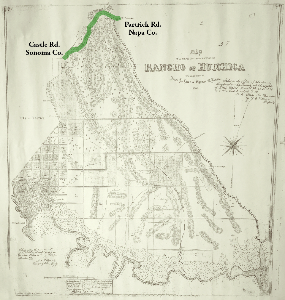
Over the next 20 years, the trail was apparently used regularly enough that it could become the boundary line between two Mexican ranchos: Rancho Huichica (“huichica” means “owl” language of the Patwin) and Rancho de Napa (“napa” is said to possibly mean many things from “bear” to “village.”). Most of the actual historical evidence of the trail is due to the arrival of Americans following the take over of California. When the U.S. took California from Mexico in 1842, all of the rancho owners had to prove what land they owned. None of them got to keep all of it, but they did get to sell it to the deluge of Americans, most of whom subdivided it and sold it again. This necessitated actual surveys for the first time. The maps of Rancho Huichica went through several iterations (see more about those here), but the final one below from 1851 shows “The Upper Road to Napa” as the curved part of the rancho’s northern boundary (in green on map).

What is the history of Trinity Rd/Dry Creek Rd?
LikeLike
Sorry to say, I do not know as I have been concentrating mostly on upper Partrick Road and the Napa Redwoods–and things tangentially connected to those. It would have started as a Native American trail, likely, and improved as a road for timbering and hillside farms. I will keep an eye out and let you know of anything I find. Thanks, Robin
LikeLike
Great study! Any information on the “Old Ridge Road’?
LikeLiked by 1 person
Is that the road up to Mt. Veeder and on?
LikeLike
Is the trail still there?
LikeLike
Hi Robin: We live past the dead end of Partrick Road. If you ever need any help with your research, let us know.
Steve and Janey Stone
LikeLike
Steve– Thank you for the invitation. I may want to walk through that area for the Padre Trial this summer. I will definitely check in with you about that then. Thanks, Robin
LikeLike